
India has one of the world's largest road networks, spanning more than 6.37 million kilometers and serving as the backbone of economic growth, logistics, and regional connectivity. However, a significant portion of this infrastructure is increasingly vulnerable to flooding caused by extreme rainfall, river overflow, urban drainage failures, and climate-related events.
Floods can severely damage highways, embankments, bridges, culverts, and pavement structures, resulting in costly repairs, traffic disruptions, and safety risks. Recognizing these challenges, the Indian Roads Congress introduced IRC SP:113-2018, a comprehensive framework that helps engineers plan, design, construct, and maintain flood-resilient road infrastructure.
Today, these guidelines are becoming even more important as agencies adopt AI flood risk road infrastructure monitoring technologies to improve preparedness, reduce damage, and strengthen highway resilience against future climate events.
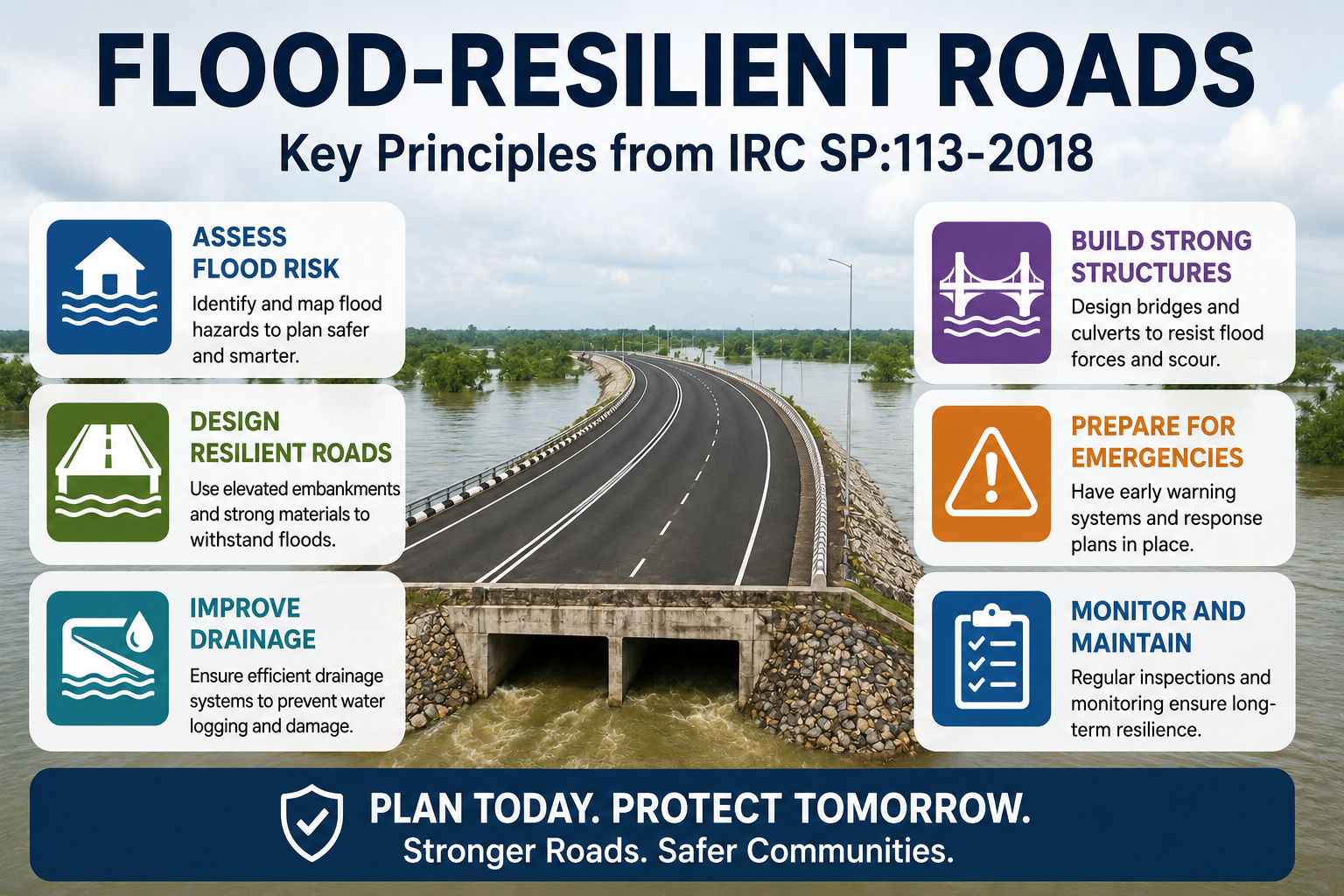
Flooding is one of the most destructive natural hazards affecting transportation networks. Roads often act as lifelines during emergencies, making their functionality critical during and after flood events.
When highways are exposed to prolonged inundation, erosion, scouring, and drainage failures, the consequences can include pavement deterioration, embankment collapse, bridge damage, and complete traffic disruption.
IRC SP:113-2018 emphasizes proactive planning rather than reactive repairs. Combined with modern highway flood vulnerability assessment AI systems, engineers can now identify vulnerable sections of road networks before disasters occur and implement mitigation measures more effectively.
As climate change continues to increase the frequency and intensity of extreme weather events, resilient infrastructure is no longer optional—it is essential.
A key principle of IRC SP:113-2018 is the identification and assessment of flood hazards before infrastructure projects are designed or upgraded.
The guideline recognizes several types of flooding that impact transportation networks:
Understanding flood behavior is crucial for determining appropriate design interventions and maintenance strategies.
Modern AI flood risk road infrastructure monitoring platforms use satellite imagery, weather intelligence, terrain data, and historical flood records to support more accurate flood hazard assessments and planning decisions.
Effective flood mitigation begins with understanding where risks exist.
IRC SP:113-2018 recommends detailed vulnerability assessments to identify road sections, bridges, culverts, and embankments most susceptible to flood-related damage.
Through flood zoning and hydrological analysis, engineers can classify infrastructure based on risk levels and prioritize investments accordingly.
Today, advanced climate risk road infrastructure AI India solutions allow authorities to create dynamic flood-risk maps that continuously update based on rainfall forecasts, water levels, and environmental conditions.
This data-driven approach improves decision-making and helps agencies allocate resources more efficiently.
One of the most important objectives of IRC SP:113-2018 is ensuring that highways remain operational during severe weather events.
The guideline recommends elevated road embankments in flood-prone areas to prevent submergence and maintain connectivity. Embankment heights should be determined using hydrological studies and projected flood levels.
Additionally, flood-resistant materials such as reinforced concrete, geosynthetics, and gabion structures are recommended to improve durability and reduce long-term maintenance costs.
Increasingly, engineers are using road drainage flood mitigation AI technologies to model water flow behavior and evaluate infrastructure performance under different flood scenarios before construction begins.
Poor drainage remains one of the primary causes of flood-related highway damage.
IRC SP:113-2018 places significant emphasis on designing effective drainage systems capable of managing both routine runoff and extreme rainfall events.
Proper drainage infrastructure includes:
Modern road drainage flood mitigation platforms can continuously monitor drainage performance, detect blockages, and identify locations where water accumulation could threaten road safety.
By combining traditional engineering principles with AI-powered monitoring, agencies can significantly improve drainage efficiency and infrastructure resilience.
Bridges are often among the most vulnerable elements during flood events.
High water velocities can cause severe scouring around bridge foundations, weakening structural stability and increasing the risk of collapse.
IRC SP:113-2018 recommends detailed hydraulic studies to ensure bridges and culverts are designed to withstand expected flood conditions throughout their service life.
The code also aligns with broader IRC 113 hydraulic road design guidelines, which emphasize adequate waterway openings, scour protection measures, and resilient foundation systems.
Today, AI-powered infrastructure monitoring tools are helping engineers detect hydraulic risks earlier and improve maintenance planning for critical structures.
Flood resilience extends beyond design and construction.
IRC SP:113-2018 highlights the importance of emergency preparedness measures, including routine inspections, drainage maintenance, embankment strengthening, and removal of obstructions that restrict water flow.
Advanced intelligent transportation systems can support emergency operations by providing real-time alerts and traffic management during severe weather events.
Modern highway resilience flood AI survey platforms help agencies monitor road conditions continuously and identify emerging threats before they escalate into major failures.
This proactive approach reduces downtime and improves public safety during disasters.
Rapid recovery is essential for restoring mobility after flood events.
IRC SP:113-2018 recommends systematic inspection procedures to evaluate pavement damage, erosion, bridge performance, and drainage functionality following floods.
Traditional inspections can be slow and resource-intensive, particularly across large networks.
Today, flood damage road assessment AI India solutions allow engineers to analyze road conditions using vehicle-mounted cameras, drones, satellite imagery, and computer vision algorithms.
Similarly, AI road condition monitoring post-flood technologies can automatically identify potholes, pavement cracking, shoulder erosion, and structural damage, enabling faster maintenance decisions.
This significantly improves recovery timelines and reduces infrastructure downtime.
A major strength of IRC SP:113-2018 is its alignment with broader national and international disaster resilience strategies.
The guideline supports the objectives of:
This integrated approach ensures that highway infrastructure planning contributes to wider disaster resilience and sustainable development goals.
Despite the availability of robust guidelines, implementation challenges remain.
Many road agencies face issues such as fragmented governance structures, budget constraints, outdated drainage systems, and rapid urbanization that increases flood exposure.
Encroachments along natural drainage channels further exacerbate flood risks in both urban and rural environments.
To address these challenges, authorities are increasingly adopting automated road damage survey India solutions, predictive analytics, and AI-driven monitoring systems that provide continuous infrastructure intelligence.
These technologies help maximize limited resources while improving long-term resilience outcomes.
As climate risks continue to evolve, highway engineering must move beyond traditional design practices.
The future of infrastructure resilience lies in combining IRC-compliant engineering principles with intelligent technologies capable of monitoring, predicting, and responding to flood threats in real time.
From AI flood risk road infrastructure monitoring and highway flood vulnerability assessment AI, digital technologies are transforming how transportation agencies manage risk and protect critical assets.
These innovations support safer roads, lower maintenance costs, and improved infrastructure performance throughout the asset lifecycle.
IRC SP:113-2018 provides a comprehensive roadmap for designing and maintaining flood-resilient highways across India. By focusing on risk assessment, drainage design, hydraulic structures, emergency preparedness, and post-disaster recovery, the guideline helps engineers create infrastructure that can withstand increasingly challenging environmental conditions.
RoadVision AI supports this transition by delivering real-time road condition monitoring, automated damage detection, infrastructure intelligence, and data-driven insights that help agencies improve resilience, reduce costs, and strengthen long-term highway performance.
RoadVision AI empowers road authorities, consultants, and infrastructure owners with advanced monitoring tools that help identify flood risks, assess road damage, and improve maintenance planning.
Book a demo today and discover how RoadVision AI can help future-proof your road infrastructure against flood-related risks.
IRC SP:113-2018 is the Indian Roads Congress guideline that provides recommendations for flood disaster mitigation in highway planning, design, construction, maintenance, and emergency management.
Floods can damage pavements, bridges, embankments, and drainage systems, leading to safety risks, economic losses, and transportation disruptions.
The guideline focuses on flood risk assessment, drainage design, hydraulic structures, embankment protection, emergency preparedness, and post-flood recovery measures.

The Autonomous Road Engineer
AI-powered road condition monitoring, asset management, & infrastructure intelligence helping agencies move from reactive maintenance to predictive road management.


.webp)
.webp)
.webp)